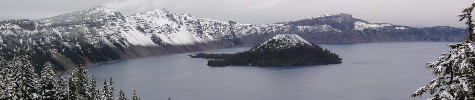
Wow! That was some ride. I left Santa Clara, CA on Friday evening, and spent the night @ Redding, CA; as planned. This morning I took off heading towards Crater Lake, OR. Now Crater Lake is a lake which was formed on the top of Mount Mazama; which was a volcano that erupted, and collapsed some 7500 years ago. To get to Crater Lake; one passes by some very small towns, some hills, and trees. Nothing really spectacular, just a relaxing ride. Then once you hit the mountain, you’ll quickly notice the temperature drop as you are going up the mountain. It was late October, and the snow had already covered the top of the mountain. Once at the top, I stopped at the restaurant/gift shop. I needed to take a break, grab a bite, and warm up a bit (even though the heated gear was already keeping me pretty warm). Once in the restaurant, I was told they they’ll be closing in about 45 minutes, as a snow storm was coming, or otherwise they would be stuck there. So, I had a quick lunch, then went out to the lake to snap a few pictures. I noticed that there was what I believe was a hotel/lounge, a museum, and a bookstore. The latter two were closed, since it was way past the Summer season. The view on the lake is beautiful. Too bad it was a very cloudy day. I enjoyed the view as much as I could, as I had to rush down the mountain to escape the awaited snow storm. I hope to come back here again, on a sunny and hot Summer day.


While I was at the gift shop, I had asked where’s the nearest gas station; as I was starting to run low on fuel. I should have filled up at the gas station available at the bottom side of the mountain; coming from the South. The lady told me there’s one back the at bottom of the mountain, South side (which is the one I passed by, and which is indicated by the GPS). However, since I was exiting & heading North, I didn’t want to ride back South, especially that the roads up the mountain were going to close (snow storm). Which meant that I would have to circumvent the mountain (South on Hwy62 then back North on Hwy 97). That, would add so much time to my already running behind trip; to Eugene, OR, and I didn’t want to make my trip any longer. The GPS showed another gas station on the North side, on Hwy 97, just North of the intersection with Hwy 138; on my route, but I was concerned that I wouldn’t make it that far. So, the lady told me there’s another gas station, some ~15km from the bottom of the mountain, on the North side. I’m like great, that’s on my way, just a little detour. And out I go.
On the way down Mount Mazama, the snow storm had already started, and all but the main road were closed. After a few kilometers, I had descended enough altitude to be below the snow storm. I looked up, and it’s kind of cool that you clearly see the snow storm line on the mountain. Just a couple of hundred meters up, and you’ll be in snow. Anyways, to conserve on fuel, I went down the mountain while having the gear on neutral, and riding the brakes (Brakes were new; I had them installed just before I left last week). So, I’m riding towards the spot where this fuel station should exist. It was actually an intimidating scenery. Trees with red leafs as far as I can see out. So, I hit the mark where there should be a gas station but nope, nothing. I keep riding, and it doesn’t look there would be anything in this remote area. I keep riding a little more, and I see a sign of some lake (Diamond Lake, OR) and tourist stuff, but no signs of a gas station (In retrospect, the gas station may have been inside that resort). I start to worry, as I may have wasted fuel, and now not enough to reach the other gas station that is on this North side of the mountain. So, I decided to ride a little more. Still nothing. Now, I make a U-turn and head for the nearest gas station on my GPS (which was the gas station on the North side, which was on my route, but that I was worried I wouldn’t have enough fuel to make it there). So now, again, I’m heading to a gas station and not sure if I’ll make it. I was ~60Km away. I hadn’t tapped in the reserve yet (which allows me for ~40Km). This means if I can get ~20Km, before getting into the reserve I should be OK! On the way there I was all tucked on my tank, to minimize wind resistance, and hence reduce fuel consumption. When going down on hills, I would put the gears in neutral. Luckily, I switched to the reserve with ~35Km left to the gas station, which I was hoping still exists, and open! Finally, I got to the gas station, it was there, and it was open. When I opened the gas tank, there was so little fuel left, maybe for another ~3Km! If this gas station was closed, I would have been screwed. At that point, I had decided, when I get back home, to buy spare fuel bottles and have them on me, on all future multi-day rides. Anyways, I filled up, and off I went.
Now, I’m heading to my final stop for the day: Eugene, OR. The time was around 6PM. Sunset is around 6:30PM, and Eugene, OR was ~ 2 hours away. I usually plan for my day to end around sunset. So, I’m running ~1.5 hours late. As the night falls, it starts raining again. Which isn’t too bad, usually. Except that I’m going through roads that go through national parks an all, so there are no lights on the road. The roads also get twisty! Fun fun fun! So now, the rain is pretty heavy, my visor is fogged up, and I can’t see. If I open my visor, the rain drops were hitting my face like needles! And then my glasses would fog-up. So, I had my visor open just enough to give me a view at the bottom, and I had my glasses lowered, so I can look through from the top of my glasses. Kind of using my glasses to protect me from the rain that’s coming through the bottom side of the open visor. This however, greatly reduces my vision to just a few meters ahead of me. Anything, beyond and it was a big watery blur. I was relying on the occasional car/truck that would be ahead of me, before they would speed aways. Obviously, I was going relatively slow in those not-so-great conditions. Another problem now, that since my vision is limited to a few meters ahead of me, and the road being very twisty, I wasn’t able to look far ahead to determine the curves of the road, and lean/turn accordingly. So, I had to rely on my GPS. I was looking at so very often to determine, how narrow/wide were the turns. I did cross the lines a few times. Luckily, no on-coming traffic during those few mishaps. Another problem, was the occasional on-coming traffic. With the rain droplets on my visor, the light off the on-coming traffic would momentarily blind my vision; making me look down, and rely 90% on my GPS to know when to turn/lean. I would also look down and see if the side/middle road markings would turn. That’s why I prefer to end my riding day by sunset 🙂
Finally, I reached the I5, and I was so happy to get to that boring Hwy! At least it’s straight and there are light posts! Made it to my hotel, ordered a pizza, took a nice hot shower, and zZZ.


